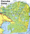
Where is Danube Delta?
The Geographic Coordinates of Danube Delta are:
From 44°47’25" to 45°37’30" Northern Latitude
From 28°44’25" to 29°46’00" Eastern Longitude.
The parallel of 45° passes through the Delta, fact which determinates characteristics of great diversity; here it is felt also the influence of Black Sea. The surface of Danube Delta is 5640 km² (it is the second as surface in Europe after the Volga Delta) out of which 82% is Romanian territory, and 18% belong to Ukraine.
Click on the picture to see a larger view from the location of Danube Delta in the world.

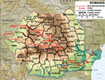
How can you reach by road Danube Delta?
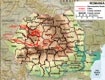
Click on the picture beside to see a larger view of the routes which we suggest to take in Romania (as roads quality, as points of interest also on the way, as speed, etc.).
For a more detailed map of Danube Delta, click on the image beside.
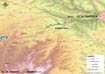
Where is Racatau?
Geographically, Maguri-Racatau area is situated at the intersection between the parallels of 46°28’N and 47°09’N and the meridians of 22°46’E and 24°12’E.
Maguri-Racatau area is situated in Gilau Mountains, in the superior pool of Somes Mic river, more exact in the middle pool of Somes Rece river, at 40 kilometers of Cluj-Napoca city.
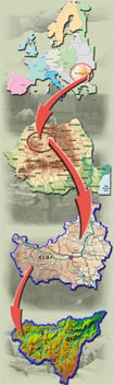
Click on the picture to see a larger view from the location of Maguri-Racatau area in Europe.
How can you reach by road Racatau?
Click on the picture beside to see a larger view of the routes which we suggest to take in Romania (as roads quality, as points of interest also on the way, as speed, etc.).
For a more detailed map of Maguri-Racatau region, click on the image beside.